234
234
Apr 19, 2013
04/13
by
KRON
tv
eye 234
favorite 0
quote 0
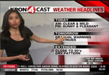
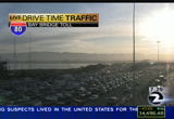
perhaps lingering seventies for napa in santa rosa. other bay area temperatures in the '60s. >> '80s, no. for fairfield, concord, walnut creek. 75 in castro valley. mid to upper 60s for downtown san francisco. 75 in san rafeal. >> checking out satellite and radar again, mainly clear conditions of the bay area. we're seeing a few more cloud associated with the system to our north bring rain to the pacific northwest. will not see any precipitation ourselves was the increase in cloud. >> temperatures will be cooler and some spots. preconditions' if you are heading to the giants game. later at 715 at at&t park expected jews in the low 60s. >> here is your extended forecast >> your kron 4 7 day around the bay forecast expect a gradual warm weather. morgan hill and gilroy could climb to the low 90s. >> plenty of sunshine perhaps morning fog. dry weather even as we end next week. >> george. >> we're looking for an incident on the upper deck of the bay bridge. if it was there is gone. the meter lights have been sped up once again. we did had a
perhaps lingering seventies for napa in santa rosa. other bay area temperatures in the '60s. >> '80s, no. for fairfield, concord, walnut creek. 75 in castro valley. mid to upper 60s for downtown san francisco. 75 in san rafeal. >> checking out satellite and radar again, mainly clear conditions of the bay area. we're seeing a few more cloud associated with the system to our north bring rain to the pacific northwest. will not see any precipitation ourselves was the increase in cloud....
166
166
Apr 19, 2013
04/13
by
KRON
tv
eye 166
favorite 0
quote 0
. >> jacqueline: it's 80 degrees right now and napa 75 in santa rosa 77 in sunnyvale a for 74 inland valleys. we have high pressures building off shore in has been keeping us clout free for the last several days. we could a little bit of that into tomorrow. continuing warming tomorrow and to the '80s. we will continue this warming trend until next week. first-class talk about the morning temperatures earlier in the morning about six or seven and we are in bold '60s. the coastline is still stuck in the '60s but into the 3:00 hour will seek a feast for most of the bay area. so let's take a look at those temperatures in your area. 7984 san jose 80 in concord, is to let antioch. 75 for hayward closer to hayward still in the '60s. so we boucicault back for saturday and sunday but not tomorrow. as for the sierra and it's going to stay dry and mild as well. at your extended forecast locally wii cc breeze to get out for saturday. as we head into early next week, we will see peak starting monday with eighties and the coastline. >> things moving well truck traffic on 80 softbound one- on-one.
. >> jacqueline: it's 80 degrees right now and napa 75 in santa rosa 77 in sunnyvale a for 74 inland valleys. we have high pressures building off shore in has been keeping us clout free for the last several days. we could a little bit of that into tomorrow. continuing warming tomorrow and to the '80s. we will continue this warming trend until next week. first-class talk about the morning temperatures earlier in the morning about six or seven and we are in bold '60s. the coastline is still...
192
192
Apr 19, 2013
04/13
by
KRON
tv
eye 192
favorite 0
quote 0
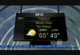
ms. '40's right now in napa. mid '40's and out so. futurecast 4 shows warming would car relatively warmer. by 12:00 mainly seventies around the bay area. along the coastline we will keep and 60. '80s possible by 3:00 p.m. today. expect mainly sunny skies. maybe an increase in cloud for the north bay. >> by 8:00 p.m. mild conditions with temperatures mainly in the '60s. here's a closer look at the afternoon highs. fremont 78. low '80s in mountain view sunnyvale. 84 year high in cupertino. seventies in the east bay. upper seventies for pittsburgh and vallejo. 84 walnut creek. mid-70s and hayward. downtown san francisco 66. low '80s for napa. 70 in berkeley. palomino 68. >> satellite and radar quiet. we are enjoying mainly clear conditions. and we kron is passing overhead bringing clouds to our region. high pressure is in control. we will notice an increase in cloud the north of the golden gate bridge. temperatures will continue to rise into the weekend as well. monday is expected to be the warmest day of the week. we are talking mid sev
ms. '40's right now in napa. mid '40's and out so. futurecast 4 shows warming would car relatively warmer. by 12:00 mainly seventies around the bay area. along the coastline we will keep and 60. '80s possible by 3:00 p.m. today. expect mainly sunny skies. maybe an increase in cloud for the north bay. >> by 8:00 p.m. mild conditions with temperatures mainly in the '60s. here's a closer look at the afternoon highs. fremont 78. low '80s in mountain view sunnyvale. 84 year high in cupertino....
136
136
Apr 19, 2013
04/13
by
KTVU
tv
eye 136
favorite 0
quote 0
napa airport is 42. temperatures are kind of stuck here. the nights are getting shorter and shorter. there is the system to the north. for us it just kind of takes the high pressure and knocks it down. it will be back. it will fire back up on sunday into monday. today and tomorrow no fog yet. i've been keeping an eye. 60s and 70s and 80s. by sunday we will bring the temps up. next week is looking warmer. cooler coast and bay. still mild to warm inland. temperatures 60s and 70s or low 80s. we are getting into that summertime pattern here by the coast. it does look like a slight pull back on saturday and then we turn things around on sunday and monday and tuesday even warmer. >>> 6:20 is the time right now. several sponsors of the boston marathon are raising money to help the victim's of monday explosions. adidas is contributing all the money raised from online sales of limited edition t-shirts. the boston beer company is donating all the money it makes from a special brew. and at & t has pledged $1 million each. the money will be used to hel
napa airport is 42. temperatures are kind of stuck here. the nights are getting shorter and shorter. there is the system to the north. for us it just kind of takes the high pressure and knocks it down. it will be back. it will fire back up on sunday into monday. today and tomorrow no fog yet. i've been keeping an eye. 60s and 70s and 80s. by sunday we will bring the temps up. next week is looking warmer. cooler coast and bay. still mild to warm inland. temperatures 60s and 70s or low 80s. we...
152
152
Apr 19, 2013
04/13
by
KNTV
tv
eye 152
favorite 0
quote 0
plenty of low 80s, 79 in napa. 80 in concord. christie smith will be live in san francisco with a report on the efforts we are making in the bay area. a run happening at 7:00 a.m. as we head through the weekend, temperatures on the warm side. 81 degrees friday, into the weekend. temperatures stay warm. let's check your driver with mike. >>> we are talking about this area off of the castro valley "y," mission boulevard, cherryland, part of hayward, looking at slowing as you approach cherry. a two-block area closed between medford and blossom. that's a major issue. you are going to have to use foothill boulevard to or from. you will have to avoid that because of a crash. a vehicle hit a ped a little while ago. there is a closure for that two-block area. they are waiting for the coroner to arrive. this could cause quite a stir. this is just north of the hayward loop there. meanwhile, 880 through that area moves smoothly. no big deal. you have the crowd coming over from the altamont pass. you know about that. that's going to mean mor
plenty of low 80s, 79 in napa. 80 in concord. christie smith will be live in san francisco with a report on the efforts we are making in the bay area. a run happening at 7:00 a.m. as we head through the weekend, temperatures on the warm side. 81 degrees friday, into the weekend. temperatures stay warm. let's check your driver with mike. >>> we are talking about this area off of the castro valley "y," mission boulevard, cherryland, part of hayward, looking at slowing as you...
397
397
Apr 19, 2013
04/13
by
KPIX
tv
eye 397
favorite 0
quote 0
and 73 right on top of the hayward fault. 82 at antioch. 82 brentwood. 81 degrees at napa. 81 dublin, 82 pleasanton. bodega bay and stinson beach might have clouds but still pleasant mid-70s for the north bay. in the look ahead, we are still keeping it warm through next week when we get a little bit of a warming trend there on monday. and in the latter half of the week, we will keep it in the mid- to upper 80s inland. right around the bay, we'll be in the mid-70s. and along the shoreline, nice and moderate. so in april, it looks a heck of a lot like july. >> doesn't it? >> we like that. >> beautiful. >> very good. >> thank you, brian. >>> 5:21 now. pg&e is beefing up security at its substations around the bay after a facility was sabotaged. heavily armed police are guarding the newark substation right now. investigators say someone cut the fiberoptic cables and used a rifle to shootout five transformers at the metcalf substation. pg&e says extra security is a precaution. >>> 5:21. coming up, the sharks go wild at the tank last night and we'll continue to follow breaking news out of wa
and 73 right on top of the hayward fault. 82 at antioch. 82 brentwood. 81 degrees at napa. 81 dublin, 82 pleasanton. bodega bay and stinson beach might have clouds but still pleasant mid-70s for the north bay. in the look ahead, we are still keeping it warm through next week when we get a little bit of a warming trend there on monday. and in the latter half of the week, we will keep it in the mid- to upper 80s inland. right around the bay, we'll be in the mid-70s. and along the shoreline, nice...
252
252
Apr 19, 2013
04/13
by
KTVU
tv
eye 252
favorite 0
quote 0
that should be your -- but concord, 47, napa at 42. cool. the breeze which was east or northeast all week long has turned a little westerly, sfo, fairfield, it's not strong but it's definite ily a change in the pattern compared to yesterday. 28 in tahoe. 40s now, 39 in reno but sacramento 46, and down in monterey we're 44. there's that system bringing rain to portland, seattle, high clouds for us. mostly sunny, cooler coast and bay. still warm inland, probably not as warm as yesterday. temperatures, 60s, 70s down about 3 to 5 degrees for many from yesterday unless you're well away from any marine influence and will still be close to yesterday's readings. i think the fog will be back, maybe take the edge of the coast and bay temps. then we turn it around sunny warmer. >>> time now 7:27. more information just coming in all the time about those two suspects in the boston marathon bombing case. what we're finding out about the suspect killed in the gun battle overnight with police and the other suspect who was still on the loose. >>> welcome bac
that should be your -- but concord, 47, napa at 42. cool. the breeze which was east or northeast all week long has turned a little westerly, sfo, fairfield, it's not strong but it's definite ily a change in the pattern compared to yesterday. 28 in tahoe. 40s now, 39 in reno but sacramento 46, and down in monterey we're 44. there's that system bringing rain to portland, seattle, high clouds for us. mostly sunny, cooler coast and bay. still warm inland, probably not as warm as yesterday....
 Live Music Archive
 Librivox Free Audio
 Metropolitan Museum
 Cleveland Museum of Art
 Internet Arcade
 Console Living Room
 Books to Borrow
 Open Library
 TV News
 Understanding 9/11